
Make a donation
Gear up for your next adventure:
As an Amazon Associate, this site earns from qualifying purchases at no extra cost to you.
Cerveteri topographic map
Click on the map to display elevation.
Make a donation
Gear up for your next adventure:
As an Amazon Associate, this site earns from qualifying purchases at no extra cost to you.
About this map
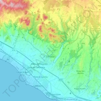
Name: Cerveteri topographic map, elevation, terrain.
Location: Cerveteri, Roma Capitale, Lazio, 00052, Italië (41.93693 11.99578 42.07847 12.20434)
Average elevation: 119 m
Minimum elevation: -2 m
Maximum elevation: 494 m
Make a donation
Gear up for your next adventure:
As an Amazon Associate, this site earns from qualifying purchases at no extra cost to you.
Other topographic maps
Click on a map to view its topography, its elevation and its terrain.
Make a donation
Gear up for your next adventure:
As an Amazon Associate, this site earns from qualifying purchases at no extra cost to you.
Lago di Traiano
Italië > Lazio > Roma Capitale > Fiumicino > Episcopio di Porto
Average elevation: 3 m