Geolocate

Poderosa topographic map

Click on the map to display elevation.

About this map

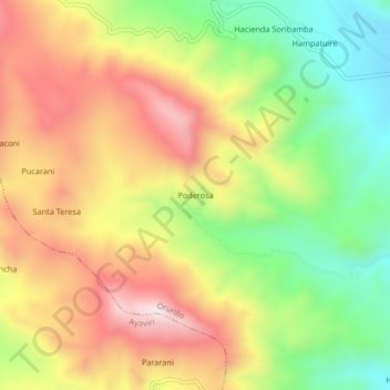
Name: Poderosa topographic map, elevation, terrain.

Location: Poderosa, Orurillo, Melgar, Puno, Perú (-14.70956 -70.61182 -14.66956 -70.57182)

Average elevation: 4,264 m

Minimum elevation: 3,974 m

Maximum elevation: 4,562 m

Gear up for your next adventure:

🎒Backpack Rain Cover - External shield to keep your entire pack dry
🚲Heavy Duty Bike Lock - Secure your bike at the trailhead or during stops
🧰Multitool Knife - Compact and versatile tool for outdoor use
🧣Merino Neck Gaiter - Protects against wind, sun, and cold at high altitudes
🥾Mountain Hiking Shoes - Shoes with superior grip for mountainous terrain

As an Amazon Associate, this site earns from qualifying purchases at no extra cost to you.