
Make a donation
Gear up for your next adventure:
As an Amazon Associate, this site earns from qualifying purchases at no extra cost to you.
Brister topographic map
Click on the map to display elevation.
Make a donation
Gear up for your next adventure:
As an Amazon Associate, this site earns from qualifying purchases at no extra cost to you.
About this map
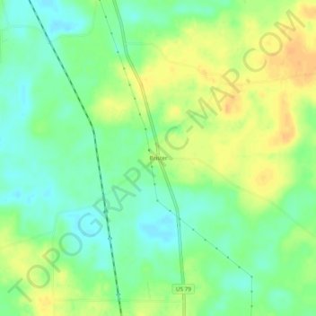
Name: Brister topographic map, elevation, terrain.
Location: Brister, Columbia County, Arkansas, United States (33.12069 -93.21211 33.16069 -93.17211)
Average elevation: 83 m
Minimum elevation: 68 m
Maximum elevation: 98 m
Make a donation
Gear up for your next adventure:
As an Amazon Associate, this site earns from qualifying purchases at no extra cost to you.
Other topographic maps
Click on a map to view its topography, its elevation and its terrain.
Magnolia
United States > Arkansas > Columbia County
Magnolia is located in southwest Arkansas, north of the center of Columbia County. The average altitude is 336 ft (102 m) above sea level according to NOAA. The surrounding region is a mix of dense forest, farm prairies, and low rolling hills.
Average elevation: 91 m