
Thank you for supporting this site ❤️
Make a donation
Make a donation
Gear up for your next adventure:
As an Amazon Associate, this site earns from qualifying purchases at no extra cost to you.
Salavisa topographic map
Click on the map to display elevation.
Thank you for supporting this site ❤️
Make a donation
Make a donation
Gear up for your next adventure:
As an Amazon Associate, this site earns from qualifying purchases at no extra cost to you.
About this map
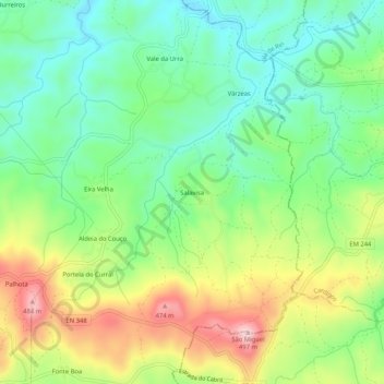
Name: Salavisa topographic map, elevation, terrain.
Location: Salavisa, Vila de Rei, Castelo Branco, Centro, Portugal (39.66271 -8.09221 39.70271 -8.05221)
Average elevation: 331 m
Minimum elevation: 238 m
Maximum elevation: 485 m
Thank you for supporting this site ❤️
Make a donation
Make a donation
Gear up for your next adventure:
As an Amazon Associate, this site earns from qualifying purchases at no extra cost to you.