
Make a donation
Gear up for your next adventure:
As an Amazon Associate, this site earns from qualifying purchases at no extra cost to you.
Pratovecchio topographic map
Click on the map to display elevation.
Make a donation
Gear up for your next adventure:
As an Amazon Associate, this site earns from qualifying purchases at no extra cost to you.
About this map
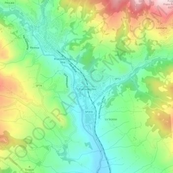
Name: Pratovecchio topographic map, elevation, terrain.
Average elevation: 538 m
Minimum elevation: 384 m
Maximum elevation: 815 m
Make a donation
Gear up for your next adventure:
As an Amazon Associate, this site earns from qualifying purchases at no extra cost to you.
Other topographic maps
Click on a map to view its topography, its elevation and its terrain.
Poppi
Der Name „Poppi“ lässt sich etymologisch auf den Begriff „poplo“, also „Anhöhe“ oder „Hügel“, aus der tyrrhenischen Sprachepoche zurückführen. Daher liegt es nahe, dass bereits vor dem 8. Jahrhundert eine Siedlung dieses Namens gegründet wurde. In Quellen erwähnt wird Poppi allerdings erst im 12. Jahrhundert.
Average elevation: 661 m
Make a donation
Gear up for your next adventure:
As an Amazon Associate, this site earns from qualifying purchases at no extra cost to you.
Monte San Savino
Zu den Ortsteilen zählen Alberoro (248 Meter Höhe über dem Meeresspiegel, ca. 515 Einwohner), Borghetto (253 m, ca. 300 Einwohner), Casina di Verniana (313 m, ca. 40 Einwohner), Gargonza (543 m, ca. 10 Einwohner), Le Vertighe (290 m, ca. 100 Einwohner), Montagnano (252 m, ca. 830 Einwohner), Palazzuolo Alto…
Average elevation: 338 m