
Thank you for supporting this site ❤️
Make a donation
Make a donation
Gear up for your next adventure:
As an Amazon Associate, this site earns from qualifying purchases at no extra cost to you.
Petra topographic map
Click on the map to display elevation.
Thank you for supporting this site ❤️
Make a donation
Make a donation
Gear up for your next adventure:
As an Amazon Associate, this site earns from qualifying purchases at no extra cost to you.
About this map
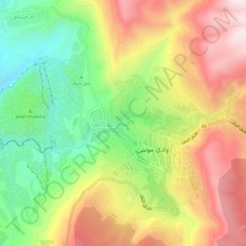
Name: Petra topographic map, elevation, terrain.
Location: Petra, Petra Sub-District, Petra District, Maan, 71810, Jordan (30.30584 35.45457 30.34584 35.49457)
Average elevation: 1,198 m
Minimum elevation: 899 m
Maximum elevation: 1,518 m
Thank you for supporting this site ❤️
Make a donation
Make a donation
Gear up for your next adventure:
As an Amazon Associate, this site earns from qualifying purchases at no extra cost to you.