
Col de Saint-Théodule topographic map
Interactive map
Click on the map to display elevation.
About this map
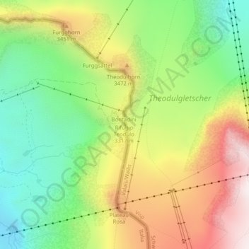
Name: Col de Saint-Théodule topographic map, elevation, terrain.
Average elevation: 3,222 m
Minimum elevation: 2,809 m
Maximum elevation: 3,756 m
Other topographic maps
Click on a map to view its topography, its elevation and its terrain.
Cervin
Italie > Vallée d'Aoste > Valtournenche
Cervin, Valtournenche, Vallée d'Aoste, Italie
Average elevation: 3,295 m
Rifugio Jean Barmasse
Italie > Vallée d'Aoste > Valtournenche > Palud
Rifugio Jean Barmasse, Coronamento Diga Cignana, Palud, Valtournenche, Vallée d'Aoste, 11028, Italie
Average elevation: 2,200 m