Geolocate

Preboan topographic map

Click on the map to display elevation.

About this map

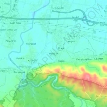
Name: Preboan topographic map, elevation, terrain.

Location: Preboan, Tegal, Kendal, Central Java, Java, Indonesia (-7.02117 110.12851 -6.98117 110.16851)

Average elevation: 30 m

Minimum elevation: 7 m

Maximum elevation: 96 m

Gear up for your next adventure:

🍽️Titanium Camping Spork - Ultralight and indestructible eating utensil
🥾Waterproof Hiking Boots - Boots keeping your feet dry in wet conditions
🥾Trail Running Boots - Durable shoes designed for trail running
🚲MTB Frame Bag - Carry tools and maps directly on your bicycle frame
🧴Waterproofing Spray - Restore the DWR coating on jackets and tents

As an Amazon Associate, this site earns from qualifying purchases at no extra cost to you.