Geolocate

Colva topographic map

Click on the map to display elevation.

About this map

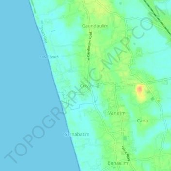
Name: Colva topographic map, elevation, terrain.

Location: Colva, Salcete, South Goa, Goa, 403708, India (15.25827 73.89971 15.29827 73.93971)

Average elevation: 8 m

Minimum elevation: 0 m

Maximum elevation: 35 m

Other topographic maps

Click on a map to view its topography, its elevation and its terrain.

Sal

India > Goa > Salcete > Parlmar Grande

Average elevation: 15 m

Gear up for your next adventure:

🧢Outdoor Visor - Breathable visor for sunny hikes
🛶Kayak Accessories - Essential gear for safe and fun kayaking adventures
🦟Insect Repellent - Keep mosquitoes and black flies away in wooded areas
🔋Solar Power Bank - Keep your GPS and devices charged during long outdoor trips
👟Trail Running Shoes - Agile footwear for fast-paced topographic exploration

As an Amazon Associate, this site earns from qualifying purchases at no extra cost to you.