
Make a donation
Gear up for your next adventure:
As an Amazon Associate, this site earns from qualifying purchases at no extra cost to you.
Chubbuck topographic map
Click on the map to display elevation.
Make a donation
Gear up for your next adventure:
As an Amazon Associate, this site earns from qualifying purchases at no extra cost to you.
Chubbuck
Chubbuck is located at 42°55′18″N 112°28′3″W / 42.92167°N 112.46750°W / 42.92167; -112.46750 (42.921648, -112.467416), at an elevation of 4,472 feet (1,363 m) above sea level.
Make a donation
Gear up for your next adventure:
As an Amazon Associate, this site earns from qualifying purchases at no extra cost to you.
About this map
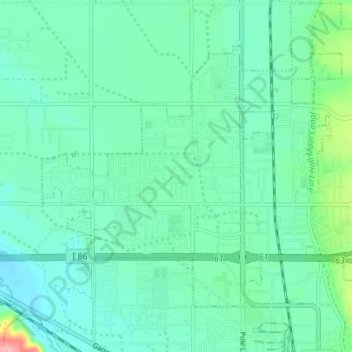
Name: Chubbuck topographic map, elevation, terrain.
Location: Chubbuck, Bannock County, Idaho, 83202, United States (42.90573 -112.50598 42.94954 -112.41312)
Average elevation: 1,377 m
Minimum elevation: 1,339 m
Maximum elevation: 1,544 m
Make a donation
Gear up for your next adventure:
As an Amazon Associate, this site earns from qualifying purchases at no extra cost to you.