
Make a donation
Gear up for your next adventure:
As an Amazon Associate, this site earns from qualifying purchases at no extra cost to you.
Wörmge topographic map
Click on the map to display elevation.
Make a donation
Gear up for your next adventure:
As an Amazon Associate, this site earns from qualifying purchases at no extra cost to you.
Wörmge
Wörmge liegt wie eine Enklave südwestlich des Kernortes Attendorn an der Listertalsperre zwischen dem Meinerzhagener Ortsteil Windebruch im Westen und dem Olper Ortsteil Sondern im Osten. Im Nordosten liegen die Attendorner Ortsteile Voßsiepen und Uelhof. Wie diese liegt Wörmge auf dem Höhenzug des Hohen Hagens, der im Biggetal beginnt und sich zwischen dem Flusstal der Lister und des Dumickebachtals bis hinauf nach Bühren zieht.
Make a donation
Gear up for your next adventure:
As an Amazon Associate, this site earns from qualifying purchases at no extra cost to you.
About this map
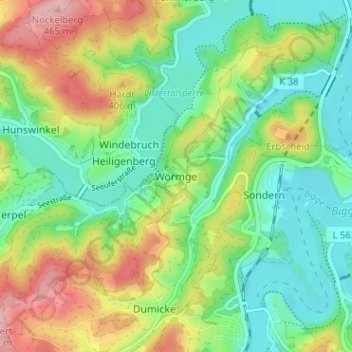
Name: Wörmge topographic map, elevation, terrain.
Location: Wörmge, Attendorn, Kreis Olpe, Nordrhein-Westfalen, Deutschland (51.05474 7.80409 51.09474 7.84409)
Average elevation: 363 m
Minimum elevation: 304 m
Maximum elevation: 466 m
Make a donation
Gear up for your next adventure:
As an Amazon Associate, this site earns from qualifying purchases at no extra cost to you.