
Thank you for supporting this site ❤️
Make a donation
Make a donation
Gear up for your next adventure:
As an Amazon Associate, this site earns from qualifying purchases at no extra cost to you.
Trouna topographic map
Click on the map to display elevation.
Thank you for supporting this site ❤️
Make a donation
Make a donation
Gear up for your next adventure:
As an Amazon Associate, this site earns from qualifying purchases at no extra cost to you.
About this map
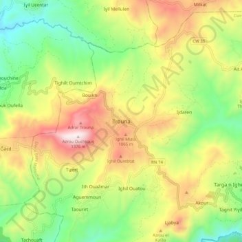
Name: Trouna topographic map, elevation, terrain.
Location: Trouna, Beni Maouche, Daïra Beni Maouche, Béjaïa, 06024, Algérie (36.46733 4.71603 36.54733 4.79603)
Average elevation: 762 m
Minimum elevation: 308 m
Maximum elevation: 1,368 m
Thank you for supporting this site ❤️
Make a donation
Make a donation
Gear up for your next adventure:
As an Amazon Associate, this site earns from qualifying purchases at no extra cost to you.