
Make a donation
Gear up for your next adventure:
As an Amazon Associate, this site earns from qualifying purchases at no extra cost to you.
Bath topographic map
Click on the map to display elevation.
Make a donation
Gear up for your next adventure:
As an Amazon Associate, this site earns from qualifying purchases at no extra cost to you.
Bath
Bath is also 100 miles (160 km) southwest of New York City and 60 miles (96 km) northwest of Philadelphia. It is also located near Wind Gap as well as the Delaware and Lehigh water gaps. Bath's elevation is 432 feet (132 m) above sea level as of 2011. The Borough is hilly and has many steep roads. There are two peaks in Bath, Hawk Mountain in the northeast, and Siegfried Hill in the southwest, which has been partially quarried out. Monocacy Creek, a tributary of the Lehigh River, flows through the town's center. A small park around the creek is located between Main and Northampton streets. The East Branch Monocacy also flows through Bath until their convergence further south. Other bodies of water include Penn-Dixie pond (the remains of a former quarry), the quarries at Keystone Cement, and numerous small ponds on the outskirts of town. Many mills operated using the flow of the Monocacy. Race and Mill street are named after them.
Make a donation
Gear up for your next adventure:
As an Amazon Associate, this site earns from qualifying purchases at no extra cost to you.
About this map
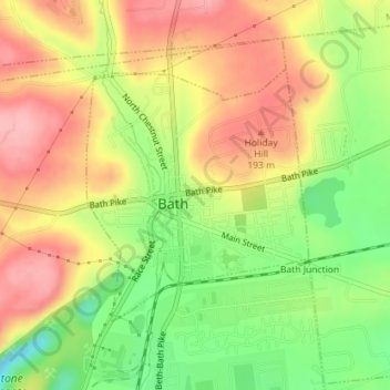
Name: Bath topographic map, elevation, terrain.
Location: Bath, Northampton County, Pennsylvania, United States (40.71836 -75.40142 40.73587 -75.38111)
Average elevation: 155 m
Minimum elevation: 79 m
Maximum elevation: 212 m
Make a donation
Gear up for your next adventure:
As an Amazon Associate, this site earns from qualifying purchases at no extra cost to you.