Geolocate

Malitbog topographic map

Click on the map to display elevation.

About this map

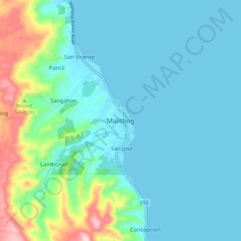
Name: Malitbog topographic map, elevation, terrain.

Location: Malitbog, Southern Leyte, Eastern Visayas, 6603, Philippines (10.12000 124.95917 10.20000 125.03917)

Average elevation: 76 m

Minimum elevation: 0 m

Maximum elevation: 426 m

Other topographic maps

Click on a map to view its topography, its elevation and its terrain.

Macrohon

Philippines > Southern Leyte

Average elevation: 33 m

Padre Burgos

Philippines > Southern Leyte

Average elevation: 38 m

Gear up for your next adventure:

🧥Fleece Jacket - Warm and lightweight jacket for layering
Backpacking Tent - Lightweight tent for long-distance hiking trips
🧥Softshell Jacket - Windproof and breathable jacket for hiking
🏕️Camping Hammock - Integrated protection for sleeping between trees
🔋Emergency Crank Radio - Weather alerts and power without needing batteries

As an Amazon Associate, this site earns from qualifying purchases at no extra cost to you.