
Make a donation
Gear up for your next adventure:
As an Amazon Associate, this site earns from qualifying purchases at no extra cost to you.
Jamalpur topographic map
Click on the map to display elevation.
Make a donation
Gear up for your next adventure:
As an Amazon Associate, this site earns from qualifying purchases at no extra cost to you.
Jamalpur
Jamalpur is located at 25°18′51″N 86°29′22″E / 25.314236°N 86.489525°E / 25.314236; 86.489525 with an average elevation of 151 metres (495 ft).
Make a donation
Gear up for your next adventure:
As an Amazon Associate, this site earns from qualifying purchases at no extra cost to you.
About this map
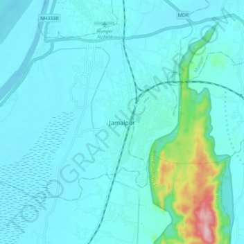
Name: Jamalpur topographic map, elevation, terrain.
Location: Jamalpur, Munger, Bihar, 811214, India (25.27388 86.44972 25.35388 86.52972)
Average elevation: 60 m
Minimum elevation: 32 m
Maximum elevation: 274 m
Make a donation
Gear up for your next adventure:
As an Amazon Associate, this site earns from qualifying purchases at no extra cost to you.