Geolocate

Codroipo topographic map

Click on the map to display elevation.

About this map

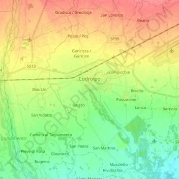
Name: Codroipo topographic map, elevation, terrain.

Location: Codroipo, Udine, Friuli-Venezia Giulia, 33033, Italy (45.90027 12.90373 46.00888 13.05010)

Average elevation: 41 m

Minimum elevation: 15 m

Maximum elevation: 73 m

Other topographic maps

Click on a map to view its topography, its elevation and its terrain.

Timau

Italy > Friuli-Venezia Giulia > Udine

Average elevation: 1,307 m

Gear up for your next adventure:

🥾Trail Hiking Socks - Comfortable socks to prevent blisters and fatigue
🧭GPS Tracker - Track your location in remote areas safely
🚲Heavy Duty Bike Lock - Secure your bike at the trailhead or during stops
🥾Hiking Shoes - Durable and comfortable shoes for trail hiking
🧣Evaporative Cooling Towel - Beat the heat during intense summer climbs

As an Amazon Associate, this site earns from qualifying purchases at no extra cost to you.