
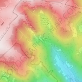
Lac de Fischboedle topographic map
Interactive map
Click on the map to display elevation.
About this map
Name: Lac de Fischboedle topographic map, elevation, terrain.
Average elevation: 1,018 m
Minimum elevation: 540 m
Maximum elevation: 1,343 m
Other topographic maps
Click on a map to view its topography, its elevation and its terrain.
Rothenbachkopf
Rothenbachkopf, Metzeral, Colmar-Ribeauvillé, Haut-Rhin, Grand Est, France métropolitaine, 68380, France
Average elevation: 1,035 m
Spitzkoepfe
Spitzkoepfe, Metzeral, Colmar-Ribeauvillé, Haut-Rhin, Grand Est, France métropolitaine, 68380, France
Average elevation: 1,130 m