Geolocate

Sourton topographic map

Click on the map to display elevation.

About this map

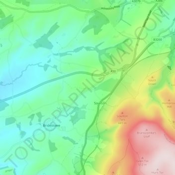
Name: Sourton topographic map, elevation, terrain.

Location: Sourton, West Devon, Devon, England, United Kingdom (50.66697 -4.13135 50.73114 -4.04438)

Average elevation: 259 m

Minimum elevation: 121 m

Maximum elevation: 568 m

Gear up for your next adventure:

👟Sport Hiking Sandals - Breathable footwear for water crossings and camp rest
🛰️Satellite Messenger - Emergency communication for areas with no cell service
🧭GPS Tracker - Track your location in remote areas safely
🧦Hiking Socks - Moisture-wicking and comfortable socks for long hikes
🧼Travel Hand Sanitizer - Keep hands clean when water is scarce

As an Amazon Associate, this site earns from qualifying purchases at no extra cost to you.