
Thank you for supporting this site ❤️
Make a donation
Make a donation
Gear up for your next adventure:
As an Amazon Associate, this site earns from qualifying purchases at no extra cost to you.
Candelara topographic map
Click on the map to display elevation.
Thank you for supporting this site ❤️
Make a donation
Make a donation
Gear up for your next adventure:
As an Amazon Associate, this site earns from qualifying purchases at no extra cost to you.
About this map
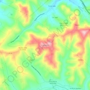
Name: Candelara topographic map, elevation, terrain.
Location: Candelara, Pesaro, Pesaro e Urbino, Marche, 61122, Italia (43.83860 12.86975 43.87860 12.90975)
Average elevation: 104 m
Minimum elevation: 22 m
Maximum elevation: 216 m
Thank you for supporting this site ❤️
Make a donation
Make a donation
Gear up for your next adventure:
As an Amazon Associate, this site earns from qualifying purchases at no extra cost to you.
Other topographic maps
Click on a map to view its topography, its elevation and its terrain.
Giardini di porta Rimini - Oltremercato
Italia > Marche > Pesaro e Urbino > Pesaro
Average elevation: 13 m