Geolocate

Raková topographic map

Click on the map to display elevation.

Raková

The municipality lies at an altitude of 427 metres and covers an area of 41.52 km2. It has a population of about 5,500 people.

Wikipedia (CC-BY-SA 3.0)

About this map

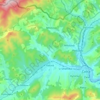
Name: Raková topographic map, elevation, terrain.

Location: Raková, District of Čadca, Region of Žilina, Central Slovakia, 023 51, Slovakia (49.40890 18.66358 49.50765 18.76412)

Average elevation: 552 m

Minimum elevation: 403 m

Maximum elevation: 1,064 m

Gear up for your next adventure:

🚲Heavy Duty Bike Lock - Secure your bike at the trailhead or during stops
🔥Camping Stove - Portable stoves to cook outdoors with ease
🦟Insect Repellent - Keep mosquitoes and black flies away in wooded areas
🧰Emergency Multi-Tool - Compact multi-tool for outdoor survival
🛏️Sleeping Bag - Warm and compact sleeping bags for outdoor camping

As an Amazon Associate, this site earns from qualifying purchases at no extra cost to you.