Geolocate

Decalachao topographic map

Click on the map to display elevation.

About this map

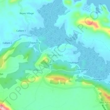
Name: Decalachao topographic map, elevation, terrain.

Location: Decalachao, Coron, Palawan, Mimaropa, Philippines (12.13314 120.06687 12.17314 120.10687)

Average elevation: 35 m

Minimum elevation: 0 m

Maximum elevation: 193 m

Other topographic maps

Click on a map to view its topography, its elevation and its terrain.

Apo Island

Philippines > Palawan > Coron

Average elevation: 22 m

Coron Island

Philippines > Palawan > Coron

Average elevation: 37 m

Bulalacao

Philippines > Palawan > Coron

Average elevation: 3 m

Bulalacao

Philippines > Palawan > Coron

Average elevation: 3 m

Pedrasa Island

Philippines > Palawan > Coron

Average elevation: 18 m

Mayanpayan Island

Philippines > Palawan > Coron

Average elevation: 7 m

Gear up for your next adventure:

🥾Hiking Shorts - Breathable shorts suitable for summer hikes
🥾All-Terrain Hiking Boots - Versatile boots for varied hiking conditions
🧰Survival Kit - Essential gear for emergencies in the wilderness
👟Leg Gaiters - Keep debris, mud, and snow out of your boots
🚑Survival Whistle - Signal for help across long distances in mountains

As an Amazon Associate, this site earns from qualifying purchases at no extra cost to you.