Geolocate

Canaman topographic map

Click on the map to display elevation.

About this map

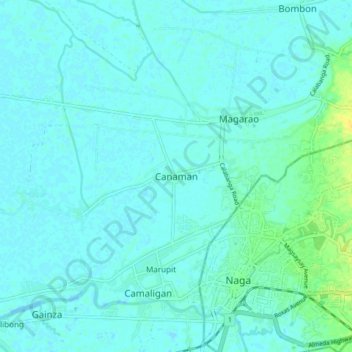
Name: Canaman topographic map, elevation, terrain.

Location: Canaman, Camarines Sur, Bicol Region, 4401, Philippines (13.60759 123.13056 13.68759 123.21056)

Average elevation: 4 m

Minimum elevation: -3 m

Maximum elevation: 21 m

Other topographic maps

Click on a map to view its topography, its elevation and its terrain.

Del Gallego

Philippines > Camarines Sur

Average elevation: 91 m

Sagñay

Philippines > Camarines Sur

Average elevation: 163 m

Caramoan

Philippines > Camarines Sur

Average elevation: 42 m

Gear up for your next adventure:

🧥Softshell Hiking Jacket - The perfect balance of wind protection and breathability
Family Camping Tent - Spacious tent suitable for family camping trips
🥾Approach Boots - Comfortable boots for hiking and climbing approaches
💧Filtered Water Bottle - Safe drinking water on the go
🥾Lightweight Hiking Shoes - Comfortable shoes for day hikes

As an Amazon Associate, this site earns from qualifying purchases at no extra cost to you.