Geolocate

Yellow Dirt topographic map

Click on the map to display elevation.

About this map

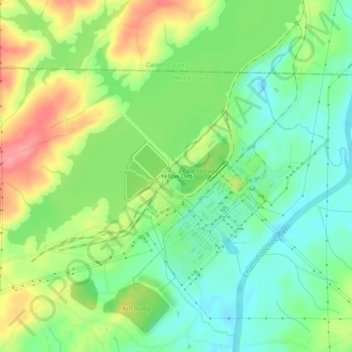
Name: Yellow Dirt topographic map, elevation, terrain.

Location: Yellow Dirt, Heard County, Georgia, United States (33.39400 -85.06078 33.43400 -85.02078)

Average elevation: 237 m

Minimum elevation: 202 m

Maximum elevation: 291 m

Other topographic maps

Click on a map to view its topography, its elevation and its terrain.

Centralhatchee

United States > Georgia > Heard County

Average elevation: 252 m

Gear up for your next adventure:

💧Collapsible Water Bottle - Space-saving water bottle for outdoor activities
🧭GPS Handheld Device - Reliable GPS navigation for outdoor adventures
🔪Outdoor Multitool - Versatile tool for repairs and food prep in the wild
🧰Emergency Multi-Tool - Compact multi-tool for outdoor survival
🧥Waterproof Jacket - Lightweight rain jackets for hiking and outdoor activities

As an Amazon Associate, this site earns from qualifying purchases at no extra cost to you.