Geolocate

Mohawk topographic map

Click on the map to display elevation.

About this map

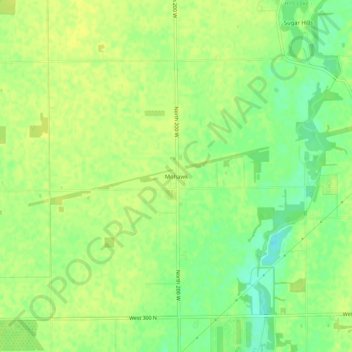
Name: Mohawk topographic map, elevation, terrain.

Location: Mohawk, Hancock County, Indiana, United States (39.82365 -85.86081 39.86365 -85.82081)

Average elevation: 265 m

Minimum elevation: 253 m

Maximum elevation: 270 m

Other topographic maps

Click on a map to view its topography, its elevation and its terrain.

Fortville

United States > Indiana > Hancock County

Average elevation: 263 m

Wilkinson

United States > Indiana > Hancock County

Average elevation: 307 m

Spring Lake

United States > Indiana > Hancock County

Average elevation: 259 m

New Palestine

United States > Indiana > Hancock County

Average elevation: 253 m

Cumberland

United States > Indiana > Hancock County

Average elevation: 261 m

Gear up for your next adventure:

🎒Hiking Daypack - Lightweight and durable backpacks for day trips and excursions
🌡️Emergency Mylar Blankets - Compact thermal protection for unexpected nights outdoors
🥾Mountaineering Boots - Supportive boots for climbing and high-altitude hiking
🧣Merino Neck Gaiter - Protects against wind, sun, and cold at high altitudes
🥤Collapsible Travel Cup - Saves space and weight in your mess kit

As an Amazon Associate, this site earns from qualifying purchases at no extra cost to you.