Geolocate

Turnerville topographic map

Interactive map

Click on the map to display elevation.

About this map

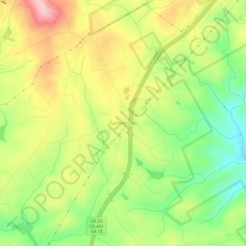
Name: Turnerville topographic map, elevation, terrain.

Location: Turnerville, Habersham County, Georgia, 30580, United States (34.66676 -83.44600 34.70676 -83.40600)

Average elevation: 463 m

Minimum elevation: 371 m

Maximum elevation: 564 m

Other topographic maps

Click on a map to view its topography, its elevation and its terrain.

Tugaloo

United States > Georgia > Habersham County > Tallulah Falls

Tugaloo, Tallulah Falls, Habersham County, Georgia, United States

Average elevation: 392 m

Habersham

United States > Georgia > Habersham County

Habersham, Habersham County, Georgia, 30544, United States

Average elevation: 409 m

Baldwin

United States > Georgia > Habersham County

Baldwin, Habersham County, Georgia, United States

Average elevation: 395 m

Clarkesville

United States > Georgia > Habersham County

Clarkesville, Habersham County, Georgia, United States

Average elevation: 418 m

Mount Airy

United States > Georgia > Habersham County

Mount Airy, Habersham County, Georgia, United States

Average elevation: 443 m

Demorest

United States > Georgia > Habersham County

Demorest, Habersham County, Georgia, United States

Average elevation: 416 m

Apple Pie Mountain

United States > Georgia > Habersham County

Apple Pie Mountain, Habersham County, Georgia, 30573, United States

Average elevation: 537 m

Cornelia

United States > Georgia > Habersham County

Cornelia, Habersham County, Georgia, United States

Average elevation: 446 m

Tallulah Falls

United States > Georgia > Habersham County

Tallulah Falls, Habersham County, Georgia, United States

Average elevation: 488 m