
Make a donation
Gear up for your next adventure:
As an Amazon Associate, this site earns from qualifying purchases at no extra cost to you.
Yakutsk Urban District topographic map
Click on the map to display elevation.
Make a donation
Gear up for your next adventure:
As an Amazon Associate, this site earns from qualifying purchases at no extra cost to you.
About this map
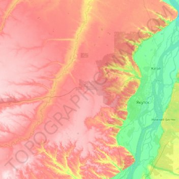
Name: Yakutsk Urban District topographic map, elevation, terrain.
Average elevation: 200 m
Minimum elevation: 78 m
Maximum elevation: 312 m
Make a donation
Gear up for your next adventure:
As an Amazon Associate, this site earns from qualifying purchases at no extra cost to you.
Other topographic maps
Click on a map to view its topography, its elevation and its terrain.
Lena River
Originating at an elevation of 1,640 meters (5,381 ft) at its source in the Baikal Mountains south of the Central Siberian Plateau, 7 kilometres (4 mi) west of Lake Baikal, the Lena flows northeast across the Lena-Angara Plateau, being joined by the Kirenga, Vitim and Olyokma. From Yakutsk it enters the…
Average elevation: 182 m
Make a donation
Gear up for your next adventure:
As an Amazon Associate, this site earns from qualifying purchases at no extra cost to you.
Lena River
Russia > Sakha Republic > Булунский наслег
Originating at an elevation of 1,640 meters (5,381 ft) at its source in the Baikal Mountains south of the Central Siberian Plateau, 7 kilometres (4 mi) west of Lake Baikal, the Lena flows northeast, being joined by the Kirenga River, Vitim River and Olyokma River. From Yakutsk it enters the Central Yakutian…
Average elevation: 20 m