
Thank you for supporting this site ❤️
Make a donation
Make a donation
Gear up for your next adventure:
As an Amazon Associate, this site earns from qualifying purchases at no extra cost to you.
Rockport topographic map
Click on the map to display elevation.
Thank you for supporting this site ❤️
Make a donation
Make a donation
Gear up for your next adventure:
As an Amazon Associate, this site earns from qualifying purchases at no extra cost to you.
About this map
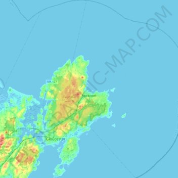
Name: Rockport topographic map, elevation, terrain.
Location: Rockport, Essex County, Massachusetts, 01966, United States (42.57989 -70.64403 42.74303 -70.49901)
Average elevation: 6 m
Minimum elevation: -4 m
Maximum elevation: 77 m
Thank you for supporting this site ❤️
Make a donation
Make a donation
Gear up for your next adventure:
As an Amazon Associate, this site earns from qualifying purchases at no extra cost to you.
Other topographic maps
Click on a map to view its topography, its elevation and its terrain.
Swampscott
United States > Massachusetts > Essex County > Swampscott > Swampscott
Average elevation: 12 m