
Kyiv Oblast topographic map
Interactive map
Click on the map to display elevation.
About this map
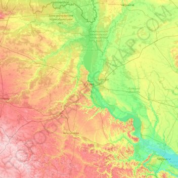
Name: Kyiv Oblast topographic map, elevation, terrain.
Location: Kyiv Oblast, Ukraine (49.17869 29.26826 51.55378 32.16103)
Average elevation: 155 m
Minimum elevation: 76 m
Maximum elevation: 331 m
Other topographic maps
Click on a map to view its topography, its elevation and its terrain.
Bilohorodka
Bilohorodka, Bilohorodka Rural Hromada, Bucha district, Kyiv Oblast, Ukraine
Average elevation: 140 m
Vyshhorod
Vyshhorod, Vyshhorod Urban Hromada, Vyshhorod Raion, Kyiv Oblast, Ukraine
Average elevation: 123 m