
Make a donation
Gear up for your next adventure:
As an Amazon Associate, this site earns from qualifying purchases at no extra cost to you.
Masatepe (Municipio) topographic map
Click on the map to display elevation.
Make a donation
Gear up for your next adventure:
As an Amazon Associate, this site earns from qualifying purchases at no extra cost to you.
Masatepe (Municipio)
Masatepe is located on top of the Plateau of towns, at an altitude of 475m, the total area can be divided into two main different types of biomes.
Make a donation
Gear up for your next adventure:
As an Amazon Associate, this site earns from qualifying purchases at no extra cost to you.
About this map
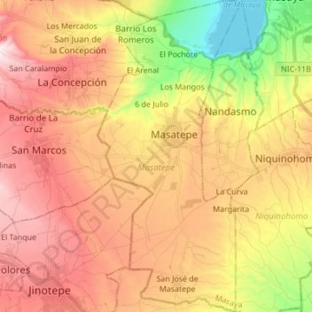
Name: Masatepe (Municipio) topographic map, elevation, terrain.
Location: Masatepe (Municipio), Masaya, 42600, Nicaragua (11.83818 -86.17819 11.97194 -86.11483)
Average elevation: 426 m
Minimum elevation: 122 m
Maximum elevation: 645 m
Make a donation
Gear up for your next adventure:
As an Amazon Associate, this site earns from qualifying purchases at no extra cost to you.
Other topographic maps
Click on a map to view its topography, its elevation and its terrain.
Volcán Masaya
In 1979, Masaya became Nicaragua's first national park, named Masaya Volcano National Park (Parque Nacional Volcán Masaya). The park has an area of 54 km2 (21 sq mi) and includes two volcanoes and five craters, as well as a range of elevations between 100 and 630 meters above sea level. In the park is a lava…
Average elevation: 449 m