Geolocate

Lawrence topographic map

Click on the map to display elevation.

About this map

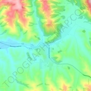
Name: Lawrence topographic map, elevation, terrain.

Location: Lawrence, Clutha District, Otago, 9532, New Zealand (-45.93293 169.66700 -45.89293 169.70700)

Average elevation: 163 m

Minimum elevation: 93 m

Maximum elevation: 307 m

Other topographic maps

Click on a map to view its topography, its elevation and its terrain.

Waipori River

New Zealand > Otago > Clutha District

Average elevation: 330 m

Ōwaka River

New Zealand > Otago > Clutha District

Average elevation: 179 m

Tahakopa River

New Zealand > Otago > Clutha District

Average elevation: 244 m

Gear up for your next adventure:

🥾Trail Running Boots - Durable shoes designed for trail running
🥾Trail Hiking Boots - Supportive boots for rough trails
🧦Hiking Liner Socks - Thin base layer to prevent friction and blisters
🗺️Topographic Maps - Detailed maps to explore trails, mountains, and wilderness areas
Lightweight Camping Tent - Portable shelter optimized for Canadian backcountry camping

As an Amazon Associate, this site earns from qualifying purchases at no extra cost to you.