
Make a donation
Gear up for your next adventure:
As an Amazon Associate, this site earns from qualifying purchases at no extra cost to you.
Odell topographic map
Click on the map to display elevation.
Make a donation
Gear up for your next adventure:
As an Amazon Associate, this site earns from qualifying purchases at no extra cost to you.
About this map
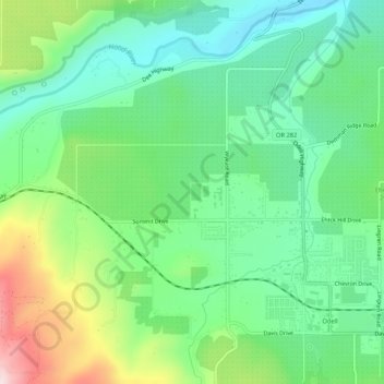
Name: Odell topographic map, elevation, terrain.
Location: Odell, Hood River County, Oregon, United States (45.62434 -121.57589 45.65142 -121.52332)
Average elevation: 244 m
Minimum elevation: 119 m
Maximum elevation: 513 m
Make a donation
Gear up for your next adventure:
As an Amazon Associate, this site earns from qualifying purchases at no extra cost to you.
Other topographic maps
Click on a map to view its topography, its elevation and its terrain.
Cascade Locks Marine Park
United States > Oregon > Hood River County > Cascade Locks
Average elevation: 72 m
Make a donation
Gear up for your next adventure:
As an Amazon Associate, this site earns from qualifying purchases at no extra cost to you.