
Make a donation
Gear up for your next adventure:
As an Amazon Associate, this site earns from qualifying purchases at no extra cost to you.
Fischbeck topographic map
Click on the map to display elevation.
Make a donation
Gear up for your next adventure:
As an Amazon Associate, this site earns from qualifying purchases at no extra cost to you.
Fischbeck
Fischbeck ist ein Stadtteil in der niedersächsischen Stadt Hessisch Oldendorf im Landkreis Hameln-Pyrmont. Der Ort liegt bei der Mündung des Nährenbachs in die Weser am Stromkilometer 142 auf einer Höhe von etwa 62 Metern über Normalnull und steigt in Richtung Nordosten zum Höhenzug Süntel kontinuierlich an. Das Zentrum von Hessisch Oldendorf sowie die Stadt Hameln befinden sich jeweils etwa sechs bis sieben Kilometer von Fischbeck entfernt.
Make a donation
Gear up for your next adventure:
As an Amazon Associate, this site earns from qualifying purchases at no extra cost to you.
About this map
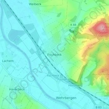
Name: Fischbeck topographic map, elevation, terrain.
Average elevation: 87 m
Minimum elevation: 57 m
Maximum elevation: 212 m
Make a donation
Gear up for your next adventure:
As an Amazon Associate, this site earns from qualifying purchases at no extra cost to you.
Other topographic maps
Click on a map to view its topography, its elevation and its terrain.
Hohenstein
Deutschland > Niedersachsen > Landkreis Hameln-Pyrmont > Hessisch Oldendorf > Rohdental
Average elevation: 243 m