
Llanfairpwllgwyngyll topographic map
Interactive map
Click on the map to display elevation.
About this map
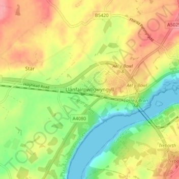
Name: Llanfairpwllgwyngyll topographic map, elevation, terrain.
Average elevation: 45 m
Minimum elevation: 0 m
Maximum elevation: 91 m
Other topographic maps
Click on a map to view its topography, its elevation and its terrain.
Château de Beaumaris
Royaume-Uni > Pays de Galles > Ynys Môn / Isle of Anglesey > Beaumaris
Château de Beaumaris, A545, Beaumaris, Ynys Môn / Isle of Anglesey, Pays de Galles, LL58 8BY, Royaume-Uni
Average elevation: 22 m