Geolocate

Belltown topographic map

Click on the map to display elevation.

About this map

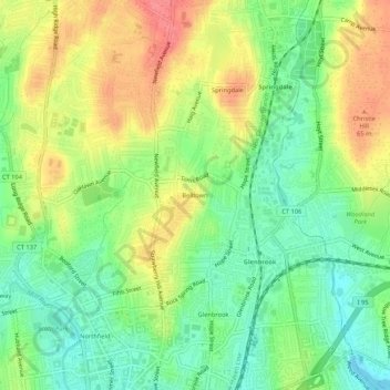
Name: Belltown topographic map, elevation, terrain.

Location: Belltown, Stamford, Western Connecticut Planning Region, Connecticut, 06906, United States (41.05704 -73.54873 41.09704 -73.50873)

Average elevation: 32 m

Minimum elevation: 0 m

Maximum elevation: 72 m

Other topographic maps

Click on a map to view its topography, its elevation and its terrain.

Gear up for your next adventure:

🧥Insulated Jacket - Keep warm in cold outdoor conditions
Lightweight Camping Tent - Portable shelter optimized for Canadian backcountry camping
🥾Approach Shoes - Shoes designed for climbing approaches and rugged trails
🧥Thermal Layer - Insulating layer for cold outdoor conditions
🥾Lightweight Hiking Boots - Boots for comfort and mobility on long hikes

As an Amazon Associate, this site earns from qualifying purchases at no extra cost to you.