
Make a donation
Gear up for your next adventure:
As an Amazon Associate, this site earns from qualifying purchases at no extra cost to you.
Kaanibungan Ridge topographic map
Click on the map to display elevation.
Make a donation
Gear up for your next adventure:
As an Amazon Associate, this site earns from qualifying purchases at no extra cost to you.
About this map
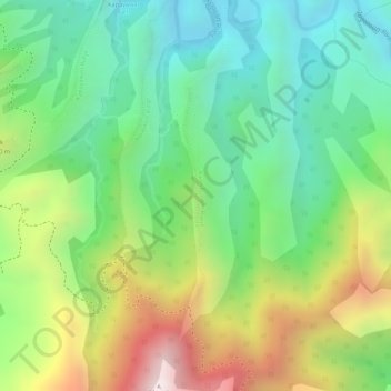
Name: Kaanibungan Ridge topographic map, elevation, terrain.
Average elevation: 723 m
Minimum elevation: 442 m
Maximum elevation: 1,162 m
Make a donation
Gear up for your next adventure:
As an Amazon Associate, this site earns from qualifying purchases at no extra cost to you.
Other topographic maps
Click on a map to view its topography, its elevation and its terrain.
Mount Kitanglad
Philippines > Bukidnon > Impasugong
Due to its high elevation, several communications and broadcasting companies constructed relay stations at the summit.
Average elevation: 2,393 m
Make a donation
Gear up for your next adventure:
As an Amazon Associate, this site earns from qualifying purchases at no extra cost to you.