Geolocate

Cañicosa topographic map

Click on the map to display elevation.

About this map

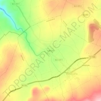
Name: Cañicosa topographic map, elevation, terrain.

Location: Cañicosa, Matabuena, Segovia, Castilla y León, 40163, España (41.08491 -3.78769 41.12491 -3.74769)

Average elevation: 1,154 m

Minimum elevation: 1,044 m

Maximum elevation: 1,242 m

Gear up for your next adventure:

🧳Compression Sacks - Maximize space in your backpack by shrinking gear
🧭Orienteering Kit - Tools for map reading and navigation in the wild
🔦LED Headtorch - Bright and durable light for night activities
🧴Sunscreen SPF - Broad-spectrum sunscreen for outdoor activities
Camping Coffee Maker - Brew fresh coffee anywhere on the topographic map

As an Amazon Associate, this site earns from qualifying purchases at no extra cost to you.