Geolocate

Cikurutug topographic map

Click on the map to display elevation.

About this map

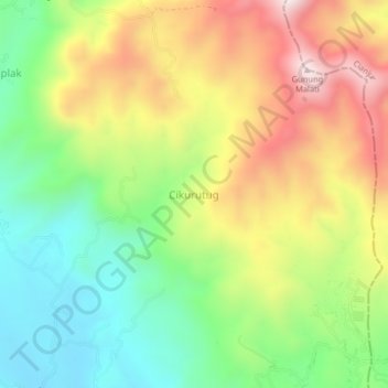
Name: Cikurutug topographic map, elevation, terrain.

Location: Cikurutug, Sukabumi, West Java, Java, Indonesia (-6.94230 107.01042 -6.90230 107.05042)

Average elevation: 838 m

Minimum elevation: 562 m

Maximum elevation: 1,197 m

Other topographic maps

Click on a map to view its topography, its elevation and its terrain.

Cibodas

Indonesia > West Java > Sukabumi > Cimenteng

Average elevation: 260 m

Cisolok

Indonesia > West Java > Sukabumi

Average elevation: 62 m

Cikahuripan

Indonesia > West Java > Sukabumi

Average elevation: 110 m

Gear up for your next adventure:

🥾Trekking Boots - Durable boots for long-distance trekking
Camping Tent - Weather-resistant tents suitable for 2 to 6 people
🌬️Windproof Camp Stove - Efficient cooking even on exposed mountain peaks
🧢Sun Hat - Wide-brim hat for sun protection
🔦LED Headtorch - Bright and durable light for night activities

As an Amazon Associate, this site earns from qualifying purchases at no extra cost to you.