Geolocate

Waiatarua topographic map

Click on the map to display elevation.

About this map
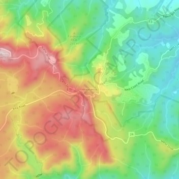
Name: Waiatarua topographic map, elevation, terrain.

Location: Waiatarua, Waitākere Ranges, Auckland, 0650, New Zealand (-36.95230 174.55816 -36.91230 174.59816)

Average elevation: 216 m

Minimum elevation: 49 m

Maximum elevation: 425 m

Other topographic maps

Click on a map to view its topography, its elevation and its terrain.

Singer Park

New Zealand > Auckland > Waitākere Ranges

Average elevation: 48 m

Lion Rock

New Zealand > Auckland > Waitākere Ranges > Piha

Average elevation: 53 m

Mauku

New Zealand > Auckland > Waitākere Ranges

Average elevation: 86 m

Gear up for your next adventure:

🛌Insulated Sleeping Pad - Critical thermal barrier between you and the cold ground
🧥Softshell Jacket - Windproof and breathable jacket for hiking
🧥Fleece Jacket - Warm and lightweight jacket for layering
💡Compact LED Flashlight - Powerful and portable flashlight for outdoor use
🥾Approach Shoes - Shoes designed for climbing approaches and rugged trails

As an Amazon Associate, this site earns from qualifying purchases at no extra cost to you.