
Diesdorf topographic map
Interactive map
Click on the map to display elevation.
About this map
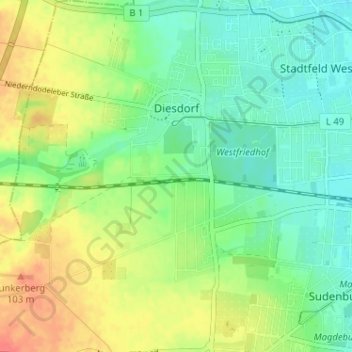
Name: Diesdorf topographic map, elevation, terrain.
Location: Diesdorf, Klein Ottersleben, Magdeburg, Saxe-Anhalt, Allemagne (52.10307 11.53341 52.14248 11.57604)
Average elevation: 74 m
Minimum elevation: 54 m
Maximum elevation: 103 m
Other topographic maps
Click on a map to view its topography, its elevation and its terrain.
Klein Ottersleben
Allemagne > Saxe-Anhalt > Klein Ottersleben
Klein Ottersleben, Magdeburg, Saxe-Anhalt, 39116, Allemagne
Average elevation: 85 m