
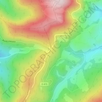
Col du Bonhomme topographic map
Interactive map
Click on the map to display elevation.
About this map
Name: Col du Bonhomme topographic map, elevation, terrain.
Average elevation: 908 m
Minimum elevation: 734 m
Maximum elevation: 1,132 m
Other topographic maps
Click on a map to view its topography, its elevation and its terrain.
Col des Bagenelles
France > Grand Est > Le Bonhomme
Col des Bagenelles, D 48, Maison Forestière du Général Bataille, Le Bonhomme, Colmar-Ribeauvillé, Haut-Rhin, Grand Est, France métropolitaine, 68650, France
Average elevation: 897 m
Col du Calvaire
France > Grand Est > Le Bonhomme
Col du Calvaire, Route des Crêtes, Maison Forestière du Général Bataille, Le Bonhomme, Saint-Dié-des-Vosges, Haut-Rhin, Grand Est, France métropolitaine, 68650, France
Average elevation: 1,073 m