
Make a donation
Gear up for your next adventure:
As an Amazon Associate, this site earns from qualifying purchases at no extra cost to you.
Vivo topographic map
Click on the map to display elevation.
Make a donation
Gear up for your next adventure:
As an Amazon Associate, this site earns from qualifying purchases at no extra cost to you.
About this map
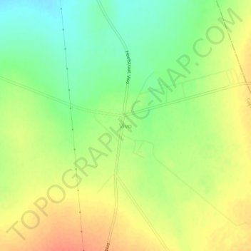
Name: Vivo topographic map, elevation, terrain.
Location: Vivo, Capricorn District Municipality, Limpopo, South Africa (-23.06389 29.25722 -23.02389 29.29722)
Average elevation: 874 m
Minimum elevation: 849 m
Maximum elevation: 896 m
Make a donation
Gear up for your next adventure:
As an Amazon Associate, this site earns from qualifying purchases at no extra cost to you.
Other topographic maps
Click on a map to view its topography, its elevation and its terrain.
Polokwane Local Municipality
South Africa > Limpopo > Capricorn District Municipality
Average elevation: 1,277 m
Lepelle-Nkumpi Local Municipality
South Africa > Limpopo > Capricorn District Municipality
Average elevation: 1,134 m
Blouberg Local Municipality
South Africa > Limpopo > Capricorn District Municipality
Average elevation: 887 m
Molemole Local Municipality
South Africa > Limpopo > Capricorn District Municipality
Average elevation: 1,084 m
Make a donation
Gear up for your next adventure:
As an Amazon Associate, this site earns from qualifying purchases at no extra cost to you.
Wolkberg Forest Wilderness Area
South Africa > Limpopo > Capricorn District Municipality > Lepelle-Nkumpi Local Municipality
Average elevation: 1,240 m
Aganang Local Municipality
South Africa > Limpopo > Capricorn District Municipality
Average elevation: 1,143 m
Lepelle-Nkumpi Local Municipality
South Africa > Limpopo > Capricorn District Municipality
Average elevation: 1,134 m
Polokwane Ward 1
South Africa > Limpopo > Capricorn District Municipality > Polokwane Local Municipality
Average elevation: 1,355 m
Make a donation
Gear up for your next adventure:
As an Amazon Associate, this site earns from qualifying purchases at no extra cost to you.
Molemole Local Municipality
South Africa > Limpopo > Capricorn District Municipality
Average elevation: 1,084 m
Blouberg Local Municipality
South Africa > Limpopo > Capricorn District Municipality
Average elevation: 887 m
Blouberg Local Municipality
South Africa > Limpopo > Capricorn District Municipality
Average elevation: 887 m
Blouberg Local Municipality
South Africa > Limpopo > Capricorn District Municipality
Average elevation: 887 m
Make a donation
Gear up for your next adventure:
As an Amazon Associate, this site earns from qualifying purchases at no extra cost to you.
Blouberg Local Municipality
South Africa > Limpopo > Capricorn District Municipality
Average elevation: 887 m