Geolocate

El Fayque topographic map

Click on the map to display elevation.

About this map

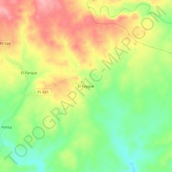
Name: El Fayque topographic map, elevation, terrain.

Location: El Fayque, Marcavelica, Sullana, Piura, Perú (-4.56342 -80.70550 -4.52342 -80.66550)

Average elevation: 305 m

Minimum elevation: 240 m

Maximum elevation: 373 m

Other topographic maps

Click on a map to view its topography, its elevation and its terrain.

Curumuy

Perú > Piura > Marcavelica

Average elevation: 51 m

Gear up for your next adventure:

🥫Freeze-Dried Meals - Lightweight, high-calorie nutrition for multi-day treks
🥾Hiking Gaiters - Protect legs and shoes from mud, snow, and debris
🔭Compact Binoculars - Lightweight optics for scouting trails and wildlife
🛁Quick-Dry Microfiber Towel - Space-saving towel that dries rapidly on the move
🕶️Polarized Sunglasses - Protect your eyes with durable polarized lenses

As an Amazon Associate, this site earns from qualifying purchases at no extra cost to you.