Geolocate

Arpora topographic map

Click on the map to display elevation.

About this map

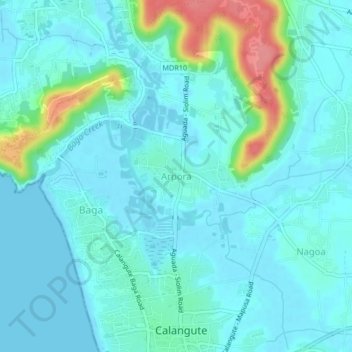
Name: Arpora topographic map, elevation, terrain.

Location: Arpora, Bardez, North Goa, Goa, 403518, India (15.54310 73.74404 15.58310 73.78404)

Average elevation: 16 m

Minimum elevation: -1 m

Maximum elevation: 90 m

Other topographic maps

Click on a map to view its topography, its elevation and its terrain.

Anjuna

India > Goa > Bardez > Anjuna

Average elevation: 14 m

Pilerne Lake

India > Goa > Bardez > Sangolda

Average elevation: 39 m

Corjuem Fort

India > Goa > Bardez > Corjuem

Average elevation: 13 m

Aguada Fort

India > Goa > Bardez > Sinquerim

Average elevation: 8 m

Anjuna

India > Goa > Bardez

Average elevation: 13 m

Anjuna Beach

India > Goa > Bardez > Anjuna

Average elevation: 10 m

Chapora Fort

India > Goa > Bardez > Chapora

Average elevation: 8 m

Gear up for your next adventure:

🚲MTB Frame Bag - Carry tools and maps directly on your bicycle frame
🕶️Polarized Sunglasses - Reduces glare from snow and water at high elevations
🔪Outdoor Multitool - Versatile tool for repairs and food prep in the wild
🥾Hiking Shorts - Breathable shorts suitable for summer hikes
🧊Insulated Water Bottle - Keeps drinks cold in summer and prevents freezing in winter

As an Amazon Associate, this site earns from qualifying purchases at no extra cost to you.