Geolocate

Caledonia topographic map

Click on the map to display elevation.

About this map

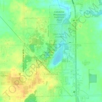
Name: Caledonia topographic map, elevation, terrain.

Location: Caledonia, Caledonia Charter Township, Kent County, Michigan, United States (42.78269 -85.54545 42.80838 -85.50677)

Average elevation: 243 m

Minimum elevation: 228 m

Maximum elevation: 258 m

Other topographic maps

Click on a map to view its topography, its elevation and its terrain.

Kentwood

United States > Michigan > Kent County > Kentwood

Average elevation: 218 m

Alton

United States > Michigan > Kent County > Vergennes Township

Average elevation: 254 m

Cordes Lake

United States > Michigan > Kent County

Average elevation: 275 m

Scram Lake

United States > Michigan > Kent County

Average elevation: 270 m

Lake Leota

United States > Michigan > Kent County > Walker

Average elevation: 199 m

Alaska

United States > Michigan > Kent County

Average elevation: 230 m

Alto

United States > Michigan > Kent County

Average elevation: 252 m

Ada

United States > Michigan > Kent County

Average elevation: 208 m

Gear up for your next adventure:

🥾Trail Hiking Shoes - Durable shoes designed for rugged trails
🧢Sun Hat - Wide-brim hat for sun protection
🧦Hiking Socks - Moisture-wicking and comfortable socks for long hikes
📷Outdoor Action Camera - Capture high-elevation views and rugged adventures
🧊Portable Cooler - Keep food and drinks cold during outdoor adventures

As an Amazon Associate, this site earns from qualifying purchases at no extra cost to you.