Geolocate

Bassum topographic map

Click on the map to display elevation.

About this map

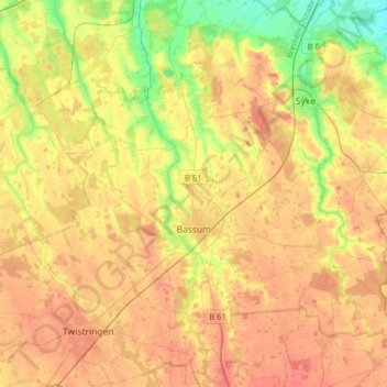
Name: Bassum topographic map, elevation, terrain.

Location: Bassum, Landkreis Diepholz, Lower Saxony, 27211, Germany (52.77128 8.62768 52.96234 8.88837)

Average elevation: 43 m

Minimum elevation: 8 m

Maximum elevation: 72 m

Other topographic maps

Click on a map to view its topography, its elevation and its terrain.

Sandbrink

Germany > Lower Saxony > Landkreis Diepholz > Burlage

Average elevation: 38 m

Gear up for your next adventure:

Backpacking Tent - Lightweight tent for long-distance hiking trips
👟Trail Running Shoes - Agile footwear for fast-paced topographic exploration
🧢Hiking Hat - Sun-protective and breathable hats for long treks
🧭Orienteering Kit - Tools for map reading and navigation in the wild
🔭Compact Monocular - One-handed bird watching and trail spotting

As an Amazon Associate, this site earns from qualifying purchases at no extra cost to you.