
Make a donation
Gear up for your next adventure:
As an Amazon Associate, this site earns from qualifying purchases at no extra cost to you.
Waterloo topographic map
Click on the map to display elevation.
Make a donation
Gear up for your next adventure:
As an Amazon Associate, this site earns from qualifying purchases at no extra cost to you.
About this map
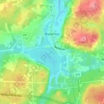
Name: Waterloo topographic map, elevation, terrain.
Location: Waterloo, La Haute-Yamaska, Québec, J0E 2N0, Canada (45.31306 -72.55143 45.35922 -72.50460)
Average elevation: 240 m
Minimum elevation: 203 m
Maximum elevation: 297 m
Make a donation
Gear up for your next adventure:
As an Amazon Associate, this site earns from qualifying purchases at no extra cost to you.
Other topographic maps
Click on a map to view its topography, its elevation and its terrain.
Mont Shefford
Canada > Québec > La Haute-Yamaska > Shefford
Le mont Shefford culmine à 526 mètres d'altitude.
Average elevation: 308 m
Parc national de la Yamaska
Canada > Québec > La Haute-Yamaska > Saint-Joachim-de-Shefford
Average elevation: 173 m