Geolocate

Lugeac topographic map

Click on the map to display elevation.

About this map

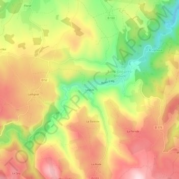
Name: Lugeac topographic map, elevation, terrain.

Location: Lugeac, Saint-Just-près-Brioude, Brioude, Haute-Loire, Auvergne-Rhône-Alpes, France métropolitaine, 43100, France (45.21493 3.32325 45.25493 3.36325)

Average elevation: 672 m

Minimum elevation: 499 m

Maximum elevation: 816 m

Other topographic maps

Click on a map to view its topography, its elevation and its terrain.

Gear up for your next adventure:

🪜Heavy Duty Carabiners - Multi-use clips for securing gear to your backpack
🏕️Camping Hammock - Integrated protection for sleeping between trees
💧Hydration Bladder - Hands-free hydration solution for long treks
🧦Crew Hiking Socks - Comfortable socks for long-distance hikes
🥾Trekking Boots - Durable boots for long-distance trekking

As an Amazon Associate, this site earns from qualifying purchases at no extra cost to you.