
Thank you for supporting this site ❤️
Make a donation
Make a donation
Gear up for your next adventure:
As an Amazon Associate, this site earns from qualifying purchases at no extra cost to you.
La Tranchée de Docelles topographic map
Click on the map to display elevation.
Thank you for supporting this site ❤️
Make a donation
Make a donation
Gear up for your next adventure:
As an Amazon Associate, this site earns from qualifying purchases at no extra cost to you.
About this map
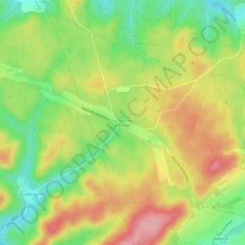
Name: La Tranchée de Docelles topographic map, elevation, terrain.
Average elevation: 416 m
Minimum elevation: 352 m
Maximum elevation: 483 m
Thank you for supporting this site ❤️
Make a donation
Make a donation
Gear up for your next adventure:
As an Amazon Associate, this site earns from qualifying purchases at no extra cost to you.
Other topographic maps
Click on a map to view its topography, its elevation and its terrain.
Château d'Épinal
France > Grand Est > Vosges > Épinal
Le château d'Épinal et les ruines de l'ancienne forteresse dominent la ville d'Épinal et la vallée de la Moselle à 387 m d'altitude.
Average elevation: 368 m