
Thank you for supporting this site ❤️
Make a donation
Make a donation
Gear up for your next adventure:
As an Amazon Associate, this site earns from qualifying purchases at no extra cost to you.
Żywiec topographic map
Click on the map to display elevation.
Thank you for supporting this site ❤️
Make a donation
Make a donation
Gear up for your next adventure:
As an Amazon Associate, this site earns from qualifying purchases at no extra cost to you.
About this map
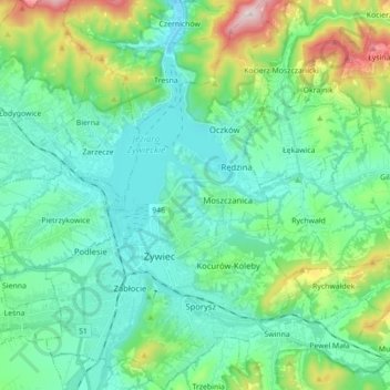
Name: Żywiec topographic map, elevation, terrain.
Location: Żywiec, Żywiec County, Silesian Voivodeship, 34-300, Poland (49.64987 19.15181 49.76312 19.26800)
Average elevation: 437 m
Minimum elevation: 319 m
Maximum elevation: 857 m
Thank you for supporting this site ❤️
Make a donation
Make a donation
Gear up for your next adventure:
As an Amazon Associate, this site earns from qualifying purchases at no extra cost to you.