Geolocate

Inca topographic map

Click on the map to display elevation.

About this map

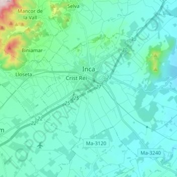
Name: Inca topographic map, elevation, terrain.

Location: Inca, Raiguer, Balearic Islands, 07300, Spain (39.67071 2.87818 39.75088 2.99970)

Average elevation: 125 m

Minimum elevation: 50 m

Maximum elevation: 626 m

Gear up for your next adventure:

🌡️Emergency Mylar Blankets - Compact thermal protection for unexpected nights outdoors
🥾Lightweight Hiking Shoes - Comfortable shoes for day hikes
🥾Hiking Shoes - Durable and comfortable shoes for trail hiking
🧥Softshell Hiking Jacket - The perfect balance of wind protection and breathability
🧥Softshell Jacket - Windproof and breathable jacket for hiking

As an Amazon Associate, this site earns from qualifying purchases at no extra cost to you.